Located in the towns of Madrid and Phillips, the Orbeton Stream Project secured a conservation easement in December 2015 on nearly 6,000 acres surrounding Orbeton Stream. The easement ensures sustainable forest management and allows public access for hiking, fishing, paddling, and hunting. The Orbeton Stream Project follows a portion of the Appalachian Trail (AT). The Read More
Explore Maine Map locations
Packard-Littlefield Farm
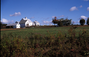
This working farm was conserved in 2004 through funding from the Land for Maine’s Future program and the Farmland Ranch Protection Program. In 2007 and 2010 the landowners, Bob and Ella Mae Packard, generously donated two additional agricultural conservation easements to the Androscoggin Land Trust, bringing the total conserved acreage of this farm to approximately Read More
Parker Pond Headland
Parker Pond is a scenic and relatively undeveloped lake situated in Fayette, a growing community 18 miles northwest of Augusta. The town has experienced a population increase of 217 percent over the past four decades as more people have discovered its natural amenities. Despite the surrounding development, though, the shores of 1,600-acre Parker Pond have Read More
Patrick Lake Access
Anglers have long enjoyed access to Patrick Lake, a 275-acre water body north of Machias that supports brown trout, chain pickerel, and white perch. They reached the lake via a boat launching ramp that many people assumed was publicly held but was in fact private. The landowner decided to sell the site as part of Read More
Pettegrow Beach
Residents of Machiasport have long considered Pettegrow Beach, a cobble beach on Buck’s Harbor, to be a community resource. The gently sloping beach is ideal for launching small boats, serving the needs of commercial fishermen, anglers, fish farmers, clammers, and recreational boaters. It is the only beach in the area that has sufficiently deep water Read More
Pleasant Bay Wildlife Management Area
The Pleasant Bay Wildlife Management Area lies near the town of Addison along the Pleasant River’s east side. The area is known for its expansive, various wildlife habitats and for its tranquil character. The preserve includes more than seven miles of waterfront along Pleasant Bay, more than 1,900 acres of intertidal marshes and mudflats, islands, Read More
Amherst Mountain Community Forest, Public Reserved Land
Description: The Amherst Mountain Community Forest is part of the Public Reserved Land system, but unlike other units, it is managed jointly with the town of Amherst. The 4,974-acre parcel is home to brook trout, white-tailed deer, black bear, Peregrine Falcons, Ruffed Grouse (partridge), and American Woodcock. The area contains two popular hiking trails, Ducktail Read More
Bald Mountain Public Reserved Land
Location: Just east of Rangeley, Franklin County Description: The Bald Mountain Public Reserved Land is a haven for outdoor enthusiasts during all four seasons. Hike the trail to the summit of Bald Mountain, particularly beautiful during the fall months, and enjoy the views of the surrounding lakes. In the summer, fishermen take to the unit’s Read More
Big Spencer Mountain Public Reserved Land
Location: Township X Range 14 WELS and Township 2 Range 13 WELS, east of Moosehead Lake, Piscataquis County Description: The Big Spencer Mountain parcel contains Big Spencer Mountain (3,230 feet), which towers over Spencer Bay on Moosehead Lake’s eastern shore. The mountain’s fire tower was active for nearly 85 years, until 1991. The 4,242-acre parcel is part Read More

