First we waste time shopping, then organizing overstuffed closets. Soon, we tire of the look and toss clothes away, generating guess what? More waste. by Ellen Taylor Portland Press Herald feature EDITOR’S NOTE: This is the fourth in a monthly five-part series about a group of professors and staff at the University of Maine at Read More
Former President of Natural Resources Council of Maine Dies at 89
by Susan Sharon Maine Public news story One of the giants in Maine’s conservation movement has died. Clinton “Bill” Townsend, an attorney, river advocate, environmental watchdog and lifelong fishermen, passed away at his home in Canaan this week at the age of 89. Bill Townsend was one of the earliest members of the Natural Resources Read More
Maine Loses Environmental Champion: Bill Townsend
NRCM mourns the loss of one of our greatest leaders and earliest members, Bill Townsend Statement by NRCM Executive Director Lisa Pohlmann It is with great sadness that I share news of the passing of Clinton B. “Bill” Townsend, a tireless advocate for Maine’s environment for more than half a century. Bill was one of Read More
The Monument Has Incredible Potential. There Should be No Uncertainty about Its Future.
By Michelle Moody, Special to the BDN Bangor Daily News op-ed The Katahdin Woods and Waters National Monument — and the communities surrounding it — is a treasure with incredible potential, if only people are allowed to realize it. This summer, my local hiking group began planning a visit to the proposed national monument. We Read More
NRCM Calls on Collins, King to Reject Trump EPA Nomination of Scott Pruitt
Statement of Lisa Pohlmann, executive director, Natural Resources Council of Maine “Scott Pruitt, President-Elect Trump’s selection to lead the EPA, is an anti-science, anti-environment ideologue. Over the last decade, he has sued the EPA to challenge nearly every major environmental protection, from the landmark Clean Power Plan to rules that protect clean water to standards Read More
Trump Suddenly has an ‘Open Mind’ on Climate Change. We Hope He Means it.
By Harold W. Borns Jr. and Sharon S. Tisher, Special to the BDN Bangor Daily News op-ed President-elect Donald Trump has denounced “climate change (global warming) bulls—-,” promised to dismantle the U.S. Climate Action Plan and Clean Power Plan and “ cancel” the Paris climate agreement. Now he claims an “open mind” when it comes Read More
Environmental Group Seeks Private Donations to Help South Portland Fight Pipeline Lawsuit
By Kelley Bouchard, Staff Writer Portland Press Herald news story The group posts a video requesting donations as the city’s legal costs head toward $1 million in the ‘Clear Skies’ ordinance case. SOUTH PORTLAND — A local environmental group has ramped up efforts to help the city defend its so-called Clear Skies ordinance in federal Read More
My Maine This Week: Popham Winter by Diane Schetky
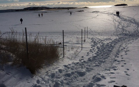
This photo was taken at Popham Beach in Phippsburg on New Year’s Day this year. With snow in the forecast today, we may see this view of Popham again soon. Photo by NRCM member Diane Schetky of Topsham, Maine To see past My Maine This Week photos, or to submit a photo of your own Read More
RSU 16 Takes a Stand to Cut Food Waste and Costs

RSU 16, comprised of schools in Mechanic Falls, Minot and Poland, which recently made news for pushing back against a waste handling company trying to bill the schools for dumpster removal, is pushing ahead with their efforts to implement recycling and composting programs. RSU 16 schools are working to reduce waste and save money. As Read More