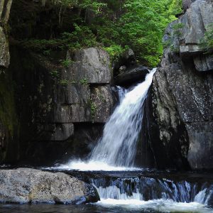
Gulf Hagas, by Wendy Weiger
This 8,400-acre parcel of mostly forested land is in the middle of Maine’s 100-Mile Wilderness. It lies right next to Gulf Hagas, the summit of Whitecap Mountain, and 11 miles of the Appalachian Trail. It was therefore the focus of conservation efforts by the Forest Society of Maine and the Appalachian Mountain Club in order to protect public access to these sites and help maintain the natural beauty and prosperity of the entire area. The site is also preserved to safeguard populations of eastern brook trout and Atlantic salmon that inhabit the region.
The parcel encompasses intact forests, scenic mountains, recreation land, and five miles of Pleasant River’s West Branch. The rugged quality of the land makes it a unique place to hike, snowshoe, snowmobile, and engage in nature study. The parcel was preserved thanks in part to funding and support provided by the Land for Maine’s Future program in 2017.
Nearby Gulf Hagas houses the popular Gulf Hagas Rim Trail, which challenges visitors with some difficult hiking through a gorge before rewarding them with fabulous views of several waterfalls. A good deal of this hike is located within the Appalachian Trail corridor, and the two trails even intersect near Screw Auger Falls. Also nearby is Whitecap Mountain, whose summit offers spectacular views of the area and can be reached via a somewhat difficult section of the Appalachian Trail.
Closest Town: Bowdoin College Grant East TWP
Activities: Hiking, Wildlife Watching, Nature Study, Snowshoeing, Hunting, Snowmobiling
Region: Maine Highlands – Piscataquis, Penobscot
Acreage: 8,402
Directions: This area is best reached via Katahdin Iron Works Road, which can be accessed via ME-11. Note that the road splits in two near the site; stay to the right.